
Leveraging Remote Sensing Tools for Irrigation Management
By Tobias E. Oker, Soils & Irrigation Advisor, UC Cooperative Extension, Kern County
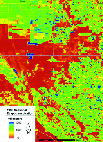
A satellite derived map showing evapotranspiration in the San Joaquin Valley for the 1990 season (Source: USGS)
As growers across California continue to navigate increasing pressure on water resources, new research from the University of California Cooperative Extension underscores the growing value of remote sensing technologies in improving irrigation efficiency and understanding crop water use.
Accurate estimates of crop evapotranspiration (ET)—the combined water lost through plant transpiration and soil evaporation—remain central to effective irrigation management. For decades, growers have relied on weather‑based tools such as the California Irrigation Management Information System (CIMIS) to guide water application throughout the season. CIMIS provides daily reference ET values derived from a statewide network of weather stations.
“CIMIS has been an invaluable resource for growers, but weather stations alone can’t fully capture the variability across California’s vast agricultural landscapes,” said Tobias E. Oker, Soils & Irrigation Advisor for UC Cooperative Extension in Kern County. “Remote sensing allows us to move beyond point measurements and see what’s happening across entire fields.”
Remote Sensing Expands the View Beyond Weather Stations
While weather stations remain essential, their limited density and the challenges of maintaining ideal site conditions can affect data accuracy. To address these limitations, researchers have increasingly turned to satellite‑based remote sensing to estimate ET at field and watershed scales.
Landsat satellites—three of which are currently operational—collect thermal and spectral data that can be translated into surface temperature and vegetation indices. These inputs allow scientists to solve the surface energy balance and estimate ET at a spatial resolution of approximately 98 × 98 feet.
“Remote sensing doesn’t replace weather stations; it enhances them,” Oker explained. “Ground‑based ET data still anchor the models, but satellites give us the bird’s‑eye view we’ve been missing.”
OpenET Brings Multiple Models Together
One of the most significant advancements in recent years is OpenET, a collaborative platform launched publicly in 2021. OpenET aggregates six independently peer‑reviewed ET models and produces an ensemble estimate designed to improve accuracy and consistency. The platform provides data for western and midwestern states and is accessible to users through a free online account.
Early comparisons between OpenET and flux tower measurements show strong agreement, with mean absolute errors ranging from 0.5 to 0.9 inches per month. A recent almond study found OpenET estimates within 13 percent of measured water use. However, some independent evaluations have reported larger discrepancies depending on crop type and environmental conditions.
“These tools are powerful, but they’re not infallible,” Oker noted. “Growers and water managers should always interpret remote sensing ET data with an understanding of model limitations and local context.”
A Rapidly Evolving Field
Additional ET products, such as those offered by Land IQ, continue to expand the landscape of remote sensing options. As computing power increases and satellite technology advances, researchers anticipate even more accurate and timely ET models in the years ahead.
“Remote sensing is moving fast,” Oker said. “The potential for improving irrigation management is enormous, and we’re just beginning to see what’s possible.”
Contact
Tobias E. Oker, Soils & Irrigation Advisor
UC Cooperative Extension, Kern County
Office: (661) 868‑6218 | Email: teoker@ucanr.edu